Aqui os pongo unos manuales variados pertenecientes a los maquinas del "foroaviones.com" (gracias especialmente a EUK136). observarlos por que no tienen ningun desperdicio. Que los disfruteis con salud. Solo en español!!!ONLY IN SPANISH!!!
Manuales Aeronauticos de EUK136

Bienvenidos a este Blog en el cual solo se pretende subir información relacionada con el mundo de la aviación y la simulación de vuelo. Se irán subiendo videos, fotos, y noticias con la idea de informar y entretener al usuario en la medida de lo posible, siempre de una forma legal y sin animo de lucro. Sentiros como en casa. *** welcome to my blog, we have the intention to entertain and inform about interesting things related to aviation and simulation. I hope you enjoy!
jueves, 30 de diciembre de 2010
miércoles, 29 de diciembre de 2010
Alair Virtual Airlines
Si quereis formar parte de una Aerolinea Virtual seria, donde el objetivo es aprender al maximo con gente de mucha experiencia y ademas divertirse, os recomiendo que os paseis por Alair Virtual Airlines. No os arrepentireis!!!
if you want to learn and enjoy with flight simulator at the same time and you are interested about IFR, have a look to this virtual airline, Alair Virtual Airlines. You will be welcome!

if you want to learn and enjoy with flight simulator at the same time and you are interested about IFR, have a look to this virtual airline, Alair Virtual Airlines. You will be welcome!
Advanced Fuel Planner for Flight Simulation
Si quieres tener un calculo del combustible necesario para una ruta en concreto con FS9 o FSX he aqui un enlace que os mostrara una especie de calculadora para que sepais la cantidad de fuel aproximada en ruta. (informacion proporcionada por Tete de Alair Virtual airlines)
estimates fuel requirements and generates realistic loadsheets for selected aircraft.
FUELPLAN²
estimates fuel requirements and generates realistic loadsheets for selected aircraft.
FUELPLAN²
IBERIA A340-300 (English)
Interesante video comentado por un piloto español de Iberia. ESTA EN INGLES
Clips from the IBERIA A340-300 (228mins) in the World Air Routes series. You can find out more about this and other DVDs by going to justplanes.com
Clips from the IBERIA A340-300 (228mins) in the World Air Routes series. You can find out more about this and other DVDs by going to justplanes.com
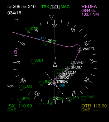
VUELO INSTRUMENTAL (IFR) - INSTRUMENTAL FLIGHT RULES
Reglas de vuelo instrumental
De Wikipedia, la enciclopedia libre
Saltar a navegación, búsqueda
Las llamadas Reglas de Vuelo Instrumental o Reglas de Vuelo por Instrumentos (más conocidas por las siglas en inglés, IFR -Instrumental Flight Rules) son el conjunto de normas y procedimientos recogidos en el Reglamento de Circulación Aérea que regulan el vuelo de aeronaves con base en el uso de instrumentos para la navegación, lo cual implica que no es necesario tener contacto visual con el terreno, como ocurre en el método de navegación bajo Reglas de Vuelo Visual (o VFR -Visual Flight Rules).

* 1 Separación de aeronaves
* 2 El controlador de tráfico aéreo
* 3 Meteorología
* 4 Procedimientos
o 4.1 Salidas y llegadas instrumentales
o 4.2 Aproximaciones
+ 4.2.1 Aproximación de precisión
+ 4.2.2 Aproximación de no precisión
o 4.3 Rutas y aerovías
* 5 Habilitación instrumental
* 6 Véase también
[editar] Separación de aeronaves
Lo más importante del vuelo instrumental es que permite la operación continua de aeronaves en los momentos en que la capacidad del piloto para ver y evitar colisiones con otras naves u obstáculos está claramente reducida o es, incluso, imposible.
Para ello, se aplican ciertos criterios de separación entre aeronaves y con el terreno. De la primera es responsable el controlador aéreo, mientras que la segunda está recogida en las cartas de navegación aeronáutica. El controlador establece la separación entre aeronaves mediante el cálculo de tiempo, de las distancias y de las velocidades entre los mismos. Obtiene tales datos de dos modos: bien mediante la velocidad, la altura, el rumbo o la posición que le transmite el piloto, bien mediante la pantalla de radar, que obtiene esos mismos datos gracias a un emisor de radio en la aeronave llamado transpondedor.
[editar] El controlador de tráfico aéreo
Generalmente, el vuelo instrumental requiere la autorización del controlador para cada fase del vuelo. El controlador proporciona rumbo o aerovía, altitud y límite (el punto más lejano al que la aeronave puede volar antes de recibir una nueva autorización. En las áreas más sobrecargadas de tráfico es usual que también se reclamen estas autorizaciones a los vuelos visuales.
En espacio aéreo no controlado, las separaciones están establecidas mediante las Cartas de Navegación, que indican altitudes mínimas para evitar el terreno y los obstáculos, las altitudes de crucero para evitar la colisión de aeronaves que vuelen en direcciones distintas. Asimismo, en el espacio aéreo no controlado los pilotos deben informar de sus intenciones utilizando una frecuencia específica de radio, para mantener alerta a los otros pilotos. En España, el espacio aéreo por encima de los 24.500 pies sobre el nivel del mar se denomina Espacio Aéreo de Clase A, y está restringido a los vuelos instrumentales.
[editar] Meteorología
Una ventaja del vuelo instrumental es la capacidad de volar en Condiciones Meteorológicas Instrumentales (siglas en inglés: IMC), esto es, aquellas condiciones que no permiten el vuelo visual. En estas condiciones, el piloto controla su avión atendiendo a la lectura de los instrumentos de vuelo, y confía al controlador su separación respecto de otras aeronaves o el terreno (a pesar de que la mayoría de los aviones de línea y cada vez más aeronaves ligeras incorporan sus propios sistemas de alarma de proximidad al terreno (GPWS) y de colisión con otras aeronaves (TCAS).
De todos modos, es importante no confundir las Reglas de Vuelo Instrumental (IFR) con las Condiciones Meteorológicas Instrumentales (IMC). La mayor parte de los aviones comerciales operan conforme a las reglas de vuelo instrumental, incluso cuando las condiciones permiten el vuelo visual. Siempre y cuando la visibilidad lo permita, el piloto utiliza como referencia primaria la observación directa, incluso para evitar colisiones con otras naves, ya que en algunos casos (en áreas con cobertura de radar limitada), el controlador carece de información sobre los aviones en vuelo visual.
Habitualmente, el piloto navega usando los instrumentos de vuelo. En áreas con cobertura de radar puede recibir también vectores –esto es, diferentes rumbos y altitudes- del controlador. También deben existir unas condiciones mínimas de visibilidad para permitir la operación, que dependen de varios factores: la habilitación de la tripulación, el equipamiento de la aeronave (algunas de ellas permiten aterrizajes completamente a ciegas, gracias al sistema de aterrizaje autómatco ILS -Instrumental Landing System-), los vientos reinantes y las radioayudas existentes en las inmediaciones del aeropuerto.
[editar] Procedimientos
Un vuelo instrumental consta de cuatro etapas: la salida, la ruta, la llegada y la aproximación. Cada una de estas etapas cuenta con sus procedimientos estándar, publicados en las cartas de navegación aeronáutica y que permiten a los vuelos instrumentales moverse de un modo ordenado y seguro, desde que el avión enciende sus motores hasta que los apaga. Estos procedimientos también permiten al piloto, en caso de fallo de comunicaciones, completar un vuelo de modo que sus intenciones puedan predecirse, tanto por el controlador como por los aviones que puedan encontrarse en la zona.

Salidas y llegadas instrumentales
Las salidas están descritas en las «cartas de salida instrumental» (SID (Standard Instrument Departure )) y describen las rutas a seguir por la aeronave en función de su destino, desde el Aeropuerto hasta que se incorpora a la Aerovía asignada. Las «cartas de llegada instrumental» (STAR (Standard Terminal Arrival Route )), por su parte, detallan la ruta desde que el avión abandona la Aerovía hasta el punto donde inicia la aproximación final a la pista.
La función de ambos procedimientos es permitir las salidas y llegadas simultáneas en el área de control del aeropuerto sin riesgos de colisión. Las rutas de salida y llegada están claramente detalladas y se fijan a partir de las radioayudas existentes (fundamentalmente los llamados [[VOR - Vhf Omni Range]] y [[NDB - Non-Directional Beacon]]), de puntos referidos a distancias y rutas a partir de tales radioayudas, llamados fijos o intersecciones, y de otros puntos marcados mediante GPS.
Aproximaciones
La aproximación a pista se detalla en las llamadas «cartas de aproximación instrumental» (IAC), que describen la ruta, tanto vertical como horizontal, hasta un punto a partir del cual el piloto debe tener contacto visual con la pista y completar el vuelo sin ayuda de los instrumentos. Dicho punto se denomina mínimo, o Altitud de Decisión. Si en este punto el piloto no tiene contacto visual con la pista, deberá frustrar el aterrizaje, de acuerdo con los procedimientos establecidos en la misma carta, y esperar instrucciones del controlador o bien dirigirse a un aeropuerto alternativo especificado en su plan de vuelo.
[editar] Aproximación de precisión
Llamamos aproximación de precisión a aquélla en la que el aeropuerto dispone de radioayudas específicas, llamadas ILS, o Sistema de Aterrizaje por Instrumentos. Esta radioayuda proporciona al avión, en el tramo final, una guía horizontal y vertical que le permite dirigirse y descender de modo seguro hasta la pista de aterrizaje.
En las versiones más sofisticadas, este sistema permite al avión tomar tierra sin intervención del piloto.
[editar] Aproximación de no precisión
Las aproximaciones de no precisión se utilizan en aeropuertos o pistas no equipados con ILS. En estos casos, las cartas conducen a la aeronave hasta un punto más o menos cercano y más o menos alineado con la pista, de modo que el piloto completa el aterrizaje de forma visual.
[editar] Rutas y aerovías
Asimismo, las rutas también están ordenadas mediante las llamadas «cartas de ruta», que establecen aerovías por las que los aviones deben volar de forma obligada. Dependiendo de su rumbo, volaran en altitudes pares o impares, para evitar así colisiones. Las aerovías se componen de puntos de referencia.
[editar] Habilitación instrumental
No todos los pilotos, ni tampoco todas las aeronaves, pueden volar bajo las reglas de vuelo instrumental. Los pilotos requieren una licencia especial y, además, acreditar que han volado recientemente bajo estas condiciones.
Del mismo modo, las aeronaves deben disponer del siguiente equipamiento:
* Dos emisores/receptores de radio para comunicaciones con los controladores
* Dos receptores VOR para contactar con las radioayudas en tierra
* Al menos un receptor NDB para contactar con los radiofaros en tierra
* Y un equipo de medición de distancias (DME) para conocer las distancias con las radioayudas.
* En caso de estar certificado un Equipo GPS con las bases de datos correspondientes
*** FUENTE WIKIPEDIA
***ENGLISH
From Wikipedia, the free encyclopedia
Jump to: navigation, search
"IFR" redirects here. For other uses, see IFR (disambiguation).
Instrument flight rules (IFR) are one of two sets of regulations governing all aspects of civil aviation aircraft operations; the other are visual flight rules (VFR).
Federal Aviation Regulations (FAR) defines IFR as: “Rules and regulations established by the FAA to govern flight under conditions in which flight by outside visual reference is not safe. IFR flight depends upon flying by reference to instruments in the flight deck, and navigation is accomplished by reference to electronic signals.[1]” It is also referred to as, “a term used by pilots and controllers to indicate the type of flight plan an aircraft is flying,” such as an IFR or VFR flight plan.[2]

* 1 Basic Information
o 1.1 Visual flight rules
o 1.2 Instrument flight rules
o 1.3 Confusing flight rules with weather conditions
* 2 Separation and clearance
* 3 Weather
* 4 Navigation
* 5 Procedures
* 6 Qualifications
* 7 References
* 8 External links
* 9 See also
[edit] Basic Information
[edit] Visual flight rules
To put instrument flight rules into context, a brief overview of VFR is necessary. Flights operating under VFR are flown solely by reference to outside visual cues, which permit navigation, orientation, and separation from terrain and other traffic. Thus, cloud ceiling and flight visibility are the most important variables for safe operations during all phases of flight.[3] The minimum weather conditions for ceiling and visibility for VFR flights are defined in FAR Part 91.155, and vary depending on the type of airspace in which the aircraft is operating, and on whether the flight is conducted during daytime or nighttime. However, typical daytime VFR minimums for most airspace is 3 statute miles of flight visibility and a cloud distance of 500' below, 1,000' above, and 2,000' feet horizontally.[4] Flight conditions reported as equal to or greater than these VFR minimums are referred to as visual meteorological conditions (VMC).
Visual flight rules are much more simplistic than IFR, and require significantly less training and practice. VFR provides a great degree of freedom, allowing pilots to go where they want, when they want, and how to get there.[5] Pilots are not required to file a flight plan, do not have to communicate with ATC (unless flying in certain types of "busier" airspace), and are not limited to following predefined published routes or flight procedures.
VFR pilots may use cockpit instruments as secondary aids to navigation and orientation, but are not required to. Instead, the view outside of the aircraft is the primary source for keeping the aircraft straight and level (orientation), flying where you intended to fly (navigation), and for not hitting anything (separation).[6]
[edit] Instrument flight rules
Instrument flight rules permit an aircraft to operate in instrument meteorological conditions (IMC), which have much lower weather minimums than VFR. Procedures and training are significantly more complex as a pilot must demonstrate competency in conducting an entire cross-country flight in IMC conditions, while controlling the aircraft solely by reference to instruments.[7]
As compared to VFR flight, instrument pilots must meticulously evaluate weather, create a very detailed flight plan based around specific instrument departure, en route, and arrival procedures, and dispatch the flight. Once airborne, the IFR pilot is then challenged to fly the aircraft in the same air traffic control (ATC) environment and weather systems that two-crew jet aircraft are using at the same time.[6][8]
[edit] Confusing flight rules with weather conditions
It is essential to differentiate between flight plan type (IFR or VFR) and weather conditions (VMC or IMC). While current and forecasted weather may be a factor in deciding which type of flight plan to file, weather conditions themselves do not affect your filed flight plan. For example, an IFR flight that encounters VMC en route does not automatically change to a VFR flight, and the flight must still follow all IFR procedures regardless of VMC or IMC.
[edit] Separation and clearance
The distance by which an aircraft avoids obstacles or other aircraft is termed separation. The most important concept of IFR flying is that separation is maintained regardless of weather conditions. In controlled airspace, Air Traffic Control (ATC) separates IFR aircraft from obstacles and other aircraft using a flight clearance based on route, time, distance, speed, and altitude. ATC monitors IFR flights on radar, or through aircraft position reports in areas where radar coverage is not available. Aircraft position reports are sent as voice radio transmissions. Aircraft position reports are not necessary if ATC reports that the aircraft is in radar contact. In the United States, a flight operating under IFR is required to provide position reports unless ATC advises a pilot that the plane is in radar contact. The pilot must resume position reports after ATC advises that radar contact has been lost, or that radar services are terminated.
IFR flights in controlled airspace require an ATC clearance for each part of the flight. A clearance always specifies a clearance limit, which is the farthest the aircraft can fly without a new clearance. In addition, a clearance typically provides a heading or route to follow, altitude, and communication parameters, such as frequencies and transponder codes.
In uncontrolled airspace, ATC clearances are unavailable. In some states a form of separation is provided to certain aircraft in uncontrolled airspace as far as is practical (often known under ICAO as an advisory service in class F airspace), but separation is not mandated nor widely provided.
Despite the protection offered by flight in controlled airspace under IFR, the ultimate responsibility for the safety of the aircraft rests with the pilot in command, who can refuse clearances.
[edit] Weather
Above clouds, but still IFR
The main purpose of IFR is the safe operation of aircraft in Instrument Meteorological Conditions (IMC). The weather is considered to be IMC when it does not meet the minimum requirements for Visual Meteorological Conditions (VMC). To operate safely in IMC, a pilot controls the aircraft relying on flight instruments, and ATC provides separation.[9]
It is important not to confuse IFR with IMC. A significant amount of IFR flying is conducted in Visual Meteorological Conditions (VMC). Any time a flight is operating in VMC, the crew is responsible for seeing and avoiding other traffic; however, since the flight is conducted under Instrument Flight Rules, ATC still provides separation services.
During flight under IFR, there are no visibility requirements, so flying through clouds is permitted. There are still minimum conditions that must be present in order for the aircraft to take off and land; these will vary according to the kind of operation, the type of navigation aids available, the location and height of terrain and obstructions in the vicinity of the airport, equipment on the aircraft, and the qualifications of the crew. For example, landing at mountain airports such as Reno (KRNO) offer significantly different instrument approaches for aircraft landing on the same runway, but from opposite directions. Aircraft approaching from the north must make visual contact with the airport at a higher altitude than a flight approaching from the south, because of rapidly rising terrain south of the airport.{FAA approach plate AL 346} This higher altitude allows a flight crew to clear the obstacle if a landing is not feasible.
Although large airliners and, increasingly, smaller aircraft now carry their own terrain awareness and warning system TAWS,[citation needed] these are primarily backup systems providing a last layer of defense if a sequence of errors or omissions causes a dangerous situation.[citation needed]
[edit] Navigation
Under IFR, the primary means of navigation are either via radio beacons on the ground, such as VORs and NDBs, or GPS. In areas of radar coverage, ATC may also assign headings to IFR aircraft, also known as radar vectors. Radar vectors are one of several methods which ATC uses to provide separation between aircraft for landing, especially in busy traffic environments; in less congested airspace, aircraft are increasingly responsible for their own traffic awareness and collision avoidance.[citation needed]
Modern Flight Management Systems have evolved sufficiently to allow a crew to plan a flight not only as to route and altitude, but to specific time of arrival at specific locations.[citation needed] This capability is used in several trial projects experimenting with four dimensional approach clearances for commercial aircraft, with time as the fourth dimension.[citation needed] These clearances allow ATC to optimize the arrival of aircraft at major airports, which increases airport capacity, and uses less fuel providing monetary and environmental benefits to airlines and the public at large respectively.[citation needed]
* Required Navigation Performance (RNP)
* ADS-B
[edit] Procedures
Main article: Flight procedure
Specific procedures allow IFR aircraft to transition safely through every stage of flight. These procedures specify how an IFR pilot should respond, even in the event of a complete radio failure, and loss of communications with ATC, including the expected aircraft course and altitude.
Here is an example of an IFR clearance, for a Cessna aircraft traveling from Palo Alto airport (KPAO) to Stockton airport (KSCK).
"Cessna 21756, cleared to Stockton Airport via turn right heading zero-six-zero within one mile of the airport. Radar Vectors San Jose, then as filed. Maintain 3,000 expect 5,000 five minutes after departure. Departure frequency is 121.3, squawk 4263."
Detailed explanation:
"Cessna 21756"
Verifies that only this specific aircraft is cleared.
"is cleared to Stockton Airport."
Clearance Limit: the farthest destination the aircraft is allowed to go under IFR (in most cases it is the destination airport).
"via turn right heading zero-six-zero within one mile of the airport."
The pilot is expected to execute the right turn to 060° without further ATC prompting within one mile of the departure airport.
"Radar Vectors San Jose"
The departure controller will provide directional guidance to the San Jose VOR.
"Then as filed."
After arriving at the San Jose VOR, the pilot will likely resume navigation without ATC prompts along the airways and intersections that were filed in their flight plan.
"Maintain 3,000 ..."
After takeoff, climb to an altitude of 3000 feet above sea level.
"... expect 5,000 five minutes after departure."
Your final altitude assignment is probably going to be 5000 feet above sea level. However, you must follow actual ATC altitude assignments throughout the flight. This portion of the clearance provides a backup if communications are lost, allowing you to proceed to climb and maintain 5000 feet.
"Departure frequency is 121.3, ..."
Contact with NORCAL Departure on the specified communication frequency, after Palo Alto Tower tells you to switch.
"... squawk 4263."
Program your transponder to 4263 so that ATC can positively identify you on radar.
Departures are described in an IFR clearance issued by ATC prior to takeoff. The departure clearance may contain an assigned heading, one or more waypoints, and an initial altitude to fly. The clearance can also specify a departure procedure (DP), or standard instrument departure (SID) that should be followed unless "NO DP" is specified in the notes section of the filed flight plan.
En route flight is described by IFR charts showing navigation aids, fixes, and standard routes called airways. Aircraft with appropriate navigational equipment such as GPS, are also often cleared for a direct-to routing, where only the destination, or a few navigational waypoints are used to describe the route that the flight will follow. ATC will assign altitudes in its initial clearance or amendments thereto, and navigational charts indicate minimum safe altitudes for airways.

The approach portion of an IFR flight may begin with a Standard Terminal Arrival Route (STAR), describing common routes to fly to arrive at an initial approach fix (IAF) from which an instrument approach commences. Instrument approaches are categorized as precision and non-precision. Despite the names, a precision approach simply indicates that vertical guidance (as well as lateral guidance) is being used. Non-precision indicates only lateral guidance.
In either case, an instrument approach will terminate either in the pilot(s) acquiring sufficient visual reference to carry out a normal landing, or in a missed approach if the required visual reference is not encountered in time. The point at which the crew of an aircraft has to make a decision to either proceed visually, or "miss" the approach is called either the Decision Altitude (DA) or Decision Height (DH) for precision approaches, and missed approach point (MAP) for non-precision approaches. During precision approaches the altitude of the aircraft is determined by the navigational instruments. For non-precision approaches the crew will descend to specific altitudes during the approach procedure, with the final altitude termed the Minimum Descent Altitude (MDA).
Some commercial aircraft are equipped with automatic landing systems that allow the aircraft to land without transitioning from instruments to visual conditions for a normal landing. Such autoland operations require specialized equipment, procedures and training, and involve the aircraft, airport, and the crew. Autoland is the only way some major airports such as Paris-Charles de Gaulle Airport remain operational every day of the year. Some modern aircraft are equipped with enhanced vision systems based on infrared sensors, that provide a day-like visual environment and allow operations in conditions and at airports that would otherwise not be suitable for a landing. Commercial aircraft also frequently use such equipment for takeoffs when takeoff minima are not met.[10]
Documents describing the approach procedure are frequently called approach plates in reference to the plate-like appearance of single-page sheet that it is printed on.
An instrument approach that terminates in a missed approach will continue using missed approach procedure information shown on the approach plate. Typically it describes a transition to a nearby navigational fix, from which the instrument approach can be attempted again. In practice an approach that terminates in a missed approach rarely flies the missed approach procedure as published. Instead, ATC will assign headings and altitudes that will assimilate the aircraft into the arriving traffic for a repeated approach attempt. The crew may also request an alternate destination, either a previously stated alternate airport, or other suitable airport considering the prevailing weather conditions.
[edit] Qualifications
To fly under IFR, a pilot must have an instrument rating, and must meet currency of experience requirements. In the United States, these currency of experience requirements include six instrument approaches, NAVAID intercepting and tracking, and holding procedures in the past six calendar months. The aircraft must also be equipped and type-certified for instrument flight, and the related navigational equipment must have been inspected within a specific period of time prior to the instrument flight.
The UK differs in its pilot-licensing practice from the U.S. In the UK any pilot can decide to which flight rules he adheres provided that the meteorological conditions for those rules are met. The pilot does need an instrument rating to fly in instrument meteorological conditions and under IFR in controlled airspace. The upshot of this is that non-instrument-qualified pilots can elect to fly under IFR in visual meteorological conditions outside controlled airspace. Compared to the rest of the world, the UK's flight crew licensing regime is somewhat unusual in its licensing for meteorological conditions and airspace, rather than flight rules. As a partial alternative to the instrument rating, the UK issues an "IMC rating", the privileges of which include flight under IFR in controlled (classes D and E) airspace and flight outside controlled airspace in instrument meteorological conditions.
In the United States, instruments required for IFR flight are those that are required for VFR flight in addition to: Heading indicator, Sensitive Altimeter adjustable for Barometric Pressure, Clock with a sweep-second pointer or digital equivalent, Attitude indicator, Radios and suitable Avionics for the route to be flown, Alternator or generator, gyroscopic rate of turn indicator that is either a Turn coordinator or the Turn and bank indicator.[11]
De Wikipedia, la enciclopedia libre
Saltar a navegación, búsqueda
Las llamadas Reglas de Vuelo Instrumental o Reglas de Vuelo por Instrumentos (más conocidas por las siglas en inglés, IFR -Instrumental Flight Rules) son el conjunto de normas y procedimientos recogidos en el Reglamento de Circulación Aérea que regulan el vuelo de aeronaves con base en el uso de instrumentos para la navegación, lo cual implica que no es necesario tener contacto visual con el terreno, como ocurre en el método de navegación bajo Reglas de Vuelo Visual (o VFR -Visual Flight Rules).

* 1 Separación de aeronaves
* 2 El controlador de tráfico aéreo
* 3 Meteorología
* 4 Procedimientos
o 4.1 Salidas y llegadas instrumentales
o 4.2 Aproximaciones
+ 4.2.1 Aproximación de precisión
+ 4.2.2 Aproximación de no precisión
o 4.3 Rutas y aerovías
* 5 Habilitación instrumental
* 6 Véase también
[editar] Separación de aeronaves
Lo más importante del vuelo instrumental es que permite la operación continua de aeronaves en los momentos en que la capacidad del piloto para ver y evitar colisiones con otras naves u obstáculos está claramente reducida o es, incluso, imposible.
Para ello, se aplican ciertos criterios de separación entre aeronaves y con el terreno. De la primera es responsable el controlador aéreo, mientras que la segunda está recogida en las cartas de navegación aeronáutica. El controlador establece la separación entre aeronaves mediante el cálculo de tiempo, de las distancias y de las velocidades entre los mismos. Obtiene tales datos de dos modos: bien mediante la velocidad, la altura, el rumbo o la posición que le transmite el piloto, bien mediante la pantalla de radar, que obtiene esos mismos datos gracias a un emisor de radio en la aeronave llamado transpondedor.
[editar] El controlador de tráfico aéreo
Generalmente, el vuelo instrumental requiere la autorización del controlador para cada fase del vuelo. El controlador proporciona rumbo o aerovía, altitud y límite (el punto más lejano al que la aeronave puede volar antes de recibir una nueva autorización. En las áreas más sobrecargadas de tráfico es usual que también se reclamen estas autorizaciones a los vuelos visuales.
En espacio aéreo no controlado, las separaciones están establecidas mediante las Cartas de Navegación, que indican altitudes mínimas para evitar el terreno y los obstáculos, las altitudes de crucero para evitar la colisión de aeronaves que vuelen en direcciones distintas. Asimismo, en el espacio aéreo no controlado los pilotos deben informar de sus intenciones utilizando una frecuencia específica de radio, para mantener alerta a los otros pilotos. En España, el espacio aéreo por encima de los 24.500 pies sobre el nivel del mar se denomina Espacio Aéreo de Clase A, y está restringido a los vuelos instrumentales.
[editar] Meteorología
Una ventaja del vuelo instrumental es la capacidad de volar en Condiciones Meteorológicas Instrumentales (siglas en inglés: IMC), esto es, aquellas condiciones que no permiten el vuelo visual. En estas condiciones, el piloto controla su avión atendiendo a la lectura de los instrumentos de vuelo, y confía al controlador su separación respecto de otras aeronaves o el terreno (a pesar de que la mayoría de los aviones de línea y cada vez más aeronaves ligeras incorporan sus propios sistemas de alarma de proximidad al terreno (GPWS) y de colisión con otras aeronaves (TCAS).
De todos modos, es importante no confundir las Reglas de Vuelo Instrumental (IFR) con las Condiciones Meteorológicas Instrumentales (IMC). La mayor parte de los aviones comerciales operan conforme a las reglas de vuelo instrumental, incluso cuando las condiciones permiten el vuelo visual. Siempre y cuando la visibilidad lo permita, el piloto utiliza como referencia primaria la observación directa, incluso para evitar colisiones con otras naves, ya que en algunos casos (en áreas con cobertura de radar limitada), el controlador carece de información sobre los aviones en vuelo visual.
Habitualmente, el piloto navega usando los instrumentos de vuelo. En áreas con cobertura de radar puede recibir también vectores –esto es, diferentes rumbos y altitudes- del controlador. También deben existir unas condiciones mínimas de visibilidad para permitir la operación, que dependen de varios factores: la habilitación de la tripulación, el equipamiento de la aeronave (algunas de ellas permiten aterrizajes completamente a ciegas, gracias al sistema de aterrizaje autómatco ILS -Instrumental Landing System-), los vientos reinantes y las radioayudas existentes en las inmediaciones del aeropuerto.
[editar] Procedimientos
Un vuelo instrumental consta de cuatro etapas: la salida, la ruta, la llegada y la aproximación. Cada una de estas etapas cuenta con sus procedimientos estándar, publicados en las cartas de navegación aeronáutica y que permiten a los vuelos instrumentales moverse de un modo ordenado y seguro, desde que el avión enciende sus motores hasta que los apaga. Estos procedimientos también permiten al piloto, en caso de fallo de comunicaciones, completar un vuelo de modo que sus intenciones puedan predecirse, tanto por el controlador como por los aviones que puedan encontrarse en la zona.

Salidas y llegadas instrumentales
Las salidas están descritas en las «cartas de salida instrumental» (SID (Standard Instrument Departure )) y describen las rutas a seguir por la aeronave en función de su destino, desde el Aeropuerto hasta que se incorpora a la Aerovía asignada. Las «cartas de llegada instrumental» (STAR (Standard Terminal Arrival Route )), por su parte, detallan la ruta desde que el avión abandona la Aerovía hasta el punto donde inicia la aproximación final a la pista.
La función de ambos procedimientos es permitir las salidas y llegadas simultáneas en el área de control del aeropuerto sin riesgos de colisión. Las rutas de salida y llegada están claramente detalladas y se fijan a partir de las radioayudas existentes (fundamentalmente los llamados [[VOR - Vhf Omni Range]] y [[NDB - Non-Directional Beacon]]), de puntos referidos a distancias y rutas a partir de tales radioayudas, llamados fijos o intersecciones, y de otros puntos marcados mediante GPS.
Aproximaciones
La aproximación a pista se detalla en las llamadas «cartas de aproximación instrumental» (IAC), que describen la ruta, tanto vertical como horizontal, hasta un punto a partir del cual el piloto debe tener contacto visual con la pista y completar el vuelo sin ayuda de los instrumentos. Dicho punto se denomina mínimo, o Altitud de Decisión. Si en este punto el piloto no tiene contacto visual con la pista, deberá frustrar el aterrizaje, de acuerdo con los procedimientos establecidos en la misma carta, y esperar instrucciones del controlador o bien dirigirse a un aeropuerto alternativo especificado en su plan de vuelo.
[editar] Aproximación de precisión

Llamamos aproximación de precisión a aquélla en la que el aeropuerto dispone de radioayudas específicas, llamadas ILS, o Sistema de Aterrizaje por Instrumentos. Esta radioayuda proporciona al avión, en el tramo final, una guía horizontal y vertical que le permite dirigirse y descender de modo seguro hasta la pista de aterrizaje.
En las versiones más sofisticadas, este sistema permite al avión tomar tierra sin intervención del piloto.
[editar] Aproximación de no precisión
Las aproximaciones de no precisión se utilizan en aeropuertos o pistas no equipados con ILS. En estos casos, las cartas conducen a la aeronave hasta un punto más o menos cercano y más o menos alineado con la pista, de modo que el piloto completa el aterrizaje de forma visual.
[editar] Rutas y aerovías
Asimismo, las rutas también están ordenadas mediante las llamadas «cartas de ruta», que establecen aerovías por las que los aviones deben volar de forma obligada. Dependiendo de su rumbo, volaran en altitudes pares o impares, para evitar así colisiones. Las aerovías se componen de puntos de referencia.
[editar] Habilitación instrumental
No todos los pilotos, ni tampoco todas las aeronaves, pueden volar bajo las reglas de vuelo instrumental. Los pilotos requieren una licencia especial y, además, acreditar que han volado recientemente bajo estas condiciones.
Del mismo modo, las aeronaves deben disponer del siguiente equipamiento:
* Dos emisores/receptores de radio para comunicaciones con los controladores
* Dos receptores VOR para contactar con las radioayudas en tierra
* Al menos un receptor NDB para contactar con los radiofaros en tierra
* Y un equipo de medición de distancias (DME) para conocer las distancias con las radioayudas.
* En caso de estar certificado un Equipo GPS con las bases de datos correspondientes
*** FUENTE WIKIPEDIA
***ENGLISH
From Wikipedia, the free encyclopedia
Jump to: navigation, search
"IFR" redirects here. For other uses, see IFR (disambiguation).
Instrument flight rules (IFR) are one of two sets of regulations governing all aspects of civil aviation aircraft operations; the other are visual flight rules (VFR).
Federal Aviation Regulations (FAR) defines IFR as: “Rules and regulations established by the FAA to govern flight under conditions in which flight by outside visual reference is not safe. IFR flight depends upon flying by reference to instruments in the flight deck, and navigation is accomplished by reference to electronic signals.[1]” It is also referred to as, “a term used by pilots and controllers to indicate the type of flight plan an aircraft is flying,” such as an IFR or VFR flight plan.[2]

* 1 Basic Information
o 1.1 Visual flight rules
o 1.2 Instrument flight rules
o 1.3 Confusing flight rules with weather conditions
* 2 Separation and clearance
* 3 Weather
* 4 Navigation
* 5 Procedures
* 6 Qualifications
* 7 References
* 8 External links
* 9 See also
[edit] Basic Information
[edit] Visual flight rules
To put instrument flight rules into context, a brief overview of VFR is necessary. Flights operating under VFR are flown solely by reference to outside visual cues, which permit navigation, orientation, and separation from terrain and other traffic. Thus, cloud ceiling and flight visibility are the most important variables for safe operations during all phases of flight.[3] The minimum weather conditions for ceiling and visibility for VFR flights are defined in FAR Part 91.155, and vary depending on the type of airspace in which the aircraft is operating, and on whether the flight is conducted during daytime or nighttime. However, typical daytime VFR minimums for most airspace is 3 statute miles of flight visibility and a cloud distance of 500' below, 1,000' above, and 2,000' feet horizontally.[4] Flight conditions reported as equal to or greater than these VFR minimums are referred to as visual meteorological conditions (VMC).
Visual flight rules are much more simplistic than IFR, and require significantly less training and practice. VFR provides a great degree of freedom, allowing pilots to go where they want, when they want, and how to get there.[5] Pilots are not required to file a flight plan, do not have to communicate with ATC (unless flying in certain types of "busier" airspace), and are not limited to following predefined published routes or flight procedures.
VFR pilots may use cockpit instruments as secondary aids to navigation and orientation, but are not required to. Instead, the view outside of the aircraft is the primary source for keeping the aircraft straight and level (orientation), flying where you intended to fly (navigation), and for not hitting anything (separation).[6]
[edit] Instrument flight rules
Instrument flight rules permit an aircraft to operate in instrument meteorological conditions (IMC), which have much lower weather minimums than VFR. Procedures and training are significantly more complex as a pilot must demonstrate competency in conducting an entire cross-country flight in IMC conditions, while controlling the aircraft solely by reference to instruments.[7]
As compared to VFR flight, instrument pilots must meticulously evaluate weather, create a very detailed flight plan based around specific instrument departure, en route, and arrival procedures, and dispatch the flight. Once airborne, the IFR pilot is then challenged to fly the aircraft in the same air traffic control (ATC) environment and weather systems that two-crew jet aircraft are using at the same time.[6][8]
[edit] Confusing flight rules with weather conditions
It is essential to differentiate between flight plan type (IFR or VFR) and weather conditions (VMC or IMC). While current and forecasted weather may be a factor in deciding which type of flight plan to file, weather conditions themselves do not affect your filed flight plan. For example, an IFR flight that encounters VMC en route does not automatically change to a VFR flight, and the flight must still follow all IFR procedures regardless of VMC or IMC.
[edit] Separation and clearance
The distance by which an aircraft avoids obstacles or other aircraft is termed separation. The most important concept of IFR flying is that separation is maintained regardless of weather conditions. In controlled airspace, Air Traffic Control (ATC) separates IFR aircraft from obstacles and other aircraft using a flight clearance based on route, time, distance, speed, and altitude. ATC monitors IFR flights on radar, or through aircraft position reports in areas where radar coverage is not available. Aircraft position reports are sent as voice radio transmissions. Aircraft position reports are not necessary if ATC reports that the aircraft is in radar contact. In the United States, a flight operating under IFR is required to provide position reports unless ATC advises a pilot that the plane is in radar contact. The pilot must resume position reports after ATC advises that radar contact has been lost, or that radar services are terminated.
IFR flights in controlled airspace require an ATC clearance for each part of the flight. A clearance always specifies a clearance limit, which is the farthest the aircraft can fly without a new clearance. In addition, a clearance typically provides a heading or route to follow, altitude, and communication parameters, such as frequencies and transponder codes.
In uncontrolled airspace, ATC clearances are unavailable. In some states a form of separation is provided to certain aircraft in uncontrolled airspace as far as is practical (often known under ICAO as an advisory service in class F airspace), but separation is not mandated nor widely provided.
Despite the protection offered by flight in controlled airspace under IFR, the ultimate responsibility for the safety of the aircraft rests with the pilot in command, who can refuse clearances.
[edit] Weather
Above clouds, but still IFR
The main purpose of IFR is the safe operation of aircraft in Instrument Meteorological Conditions (IMC). The weather is considered to be IMC when it does not meet the minimum requirements for Visual Meteorological Conditions (VMC). To operate safely in IMC, a pilot controls the aircraft relying on flight instruments, and ATC provides separation.[9]
It is important not to confuse IFR with IMC. A significant amount of IFR flying is conducted in Visual Meteorological Conditions (VMC). Any time a flight is operating in VMC, the crew is responsible for seeing and avoiding other traffic; however, since the flight is conducted under Instrument Flight Rules, ATC still provides separation services.
During flight under IFR, there are no visibility requirements, so flying through clouds is permitted. There are still minimum conditions that must be present in order for the aircraft to take off and land; these will vary according to the kind of operation, the type of navigation aids available, the location and height of terrain and obstructions in the vicinity of the airport, equipment on the aircraft, and the qualifications of the crew. For example, landing at mountain airports such as Reno (KRNO) offer significantly different instrument approaches for aircraft landing on the same runway, but from opposite directions. Aircraft approaching from the north must make visual contact with the airport at a higher altitude than a flight approaching from the south, because of rapidly rising terrain south of the airport.{FAA approach plate AL 346} This higher altitude allows a flight crew to clear the obstacle if a landing is not feasible.
Although large airliners and, increasingly, smaller aircraft now carry their own terrain awareness and warning system TAWS,[citation needed] these are primarily backup systems providing a last layer of defense if a sequence of errors or omissions causes a dangerous situation.[citation needed]
[edit] Navigation
Under IFR, the primary means of navigation are either via radio beacons on the ground, such as VORs and NDBs, or GPS. In areas of radar coverage, ATC may also assign headings to IFR aircraft, also known as radar vectors. Radar vectors are one of several methods which ATC uses to provide separation between aircraft for landing, especially in busy traffic environments; in less congested airspace, aircraft are increasingly responsible for their own traffic awareness and collision avoidance.[citation needed]
Modern Flight Management Systems have evolved sufficiently to allow a crew to plan a flight not only as to route and altitude, but to specific time of arrival at specific locations.[citation needed] This capability is used in several trial projects experimenting with four dimensional approach clearances for commercial aircraft, with time as the fourth dimension.[citation needed] These clearances allow ATC to optimize the arrival of aircraft at major airports, which increases airport capacity, and uses less fuel providing monetary and environmental benefits to airlines and the public at large respectively.[citation needed]
* Required Navigation Performance (RNP)
* ADS-B
[edit] Procedures
Main article: Flight procedure
Specific procedures allow IFR aircraft to transition safely through every stage of flight. These procedures specify how an IFR pilot should respond, even in the event of a complete radio failure, and loss of communications with ATC, including the expected aircraft course and altitude.
Here is an example of an IFR clearance, for a Cessna aircraft traveling from Palo Alto airport (KPAO) to Stockton airport (KSCK).
"Cessna 21756, cleared to Stockton Airport via turn right heading zero-six-zero within one mile of the airport. Radar Vectors San Jose, then as filed. Maintain 3,000 expect 5,000 five minutes after departure. Departure frequency is 121.3, squawk 4263."
Detailed explanation:
"Cessna 21756"
Verifies that only this specific aircraft is cleared.
"is cleared to Stockton Airport."
Clearance Limit: the farthest destination the aircraft is allowed to go under IFR (in most cases it is the destination airport).
"via turn right heading zero-six-zero within one mile of the airport."
The pilot is expected to execute the right turn to 060° without further ATC prompting within one mile of the departure airport.
"Radar Vectors San Jose"
The departure controller will provide directional guidance to the San Jose VOR.
"Then as filed."
After arriving at the San Jose VOR, the pilot will likely resume navigation without ATC prompts along the airways and intersections that were filed in their flight plan.
"Maintain 3,000 ..."
After takeoff, climb to an altitude of 3000 feet above sea level.
"... expect 5,000 five minutes after departure."
Your final altitude assignment is probably going to be 5000 feet above sea level. However, you must follow actual ATC altitude assignments throughout the flight. This portion of the clearance provides a backup if communications are lost, allowing you to proceed to climb and maintain 5000 feet.
"Departure frequency is 121.3, ..."
Contact with NORCAL Departure on the specified communication frequency, after Palo Alto Tower tells you to switch.
"... squawk 4263."
Program your transponder to 4263 so that ATC can positively identify you on radar.
Departures are described in an IFR clearance issued by ATC prior to takeoff. The departure clearance may contain an assigned heading, one or more waypoints, and an initial altitude to fly. The clearance can also specify a departure procedure (DP), or standard instrument departure (SID) that should be followed unless "NO DP" is specified in the notes section of the filed flight plan.
En route flight is described by IFR charts showing navigation aids, fixes, and standard routes called airways. Aircraft with appropriate navigational equipment such as GPS, are also often cleared for a direct-to routing, where only the destination, or a few navigational waypoints are used to describe the route that the flight will follow. ATC will assign altitudes in its initial clearance or amendments thereto, and navigational charts indicate minimum safe altitudes for airways.

The approach portion of an IFR flight may begin with a Standard Terminal Arrival Route (STAR), describing common routes to fly to arrive at an initial approach fix (IAF) from which an instrument approach commences. Instrument approaches are categorized as precision and non-precision. Despite the names, a precision approach simply indicates that vertical guidance (as well as lateral guidance) is being used. Non-precision indicates only lateral guidance.
In either case, an instrument approach will terminate either in the pilot(s) acquiring sufficient visual reference to carry out a normal landing, or in a missed approach if the required visual reference is not encountered in time. The point at which the crew of an aircraft has to make a decision to either proceed visually, or "miss" the approach is called either the Decision Altitude (DA) or Decision Height (DH) for precision approaches, and missed approach point (MAP) for non-precision approaches. During precision approaches the altitude of the aircraft is determined by the navigational instruments. For non-precision approaches the crew will descend to specific altitudes during the approach procedure, with the final altitude termed the Minimum Descent Altitude (MDA).
Some commercial aircraft are equipped with automatic landing systems that allow the aircraft to land without transitioning from instruments to visual conditions for a normal landing. Such autoland operations require specialized equipment, procedures and training, and involve the aircraft, airport, and the crew. Autoland is the only way some major airports such as Paris-Charles de Gaulle Airport remain operational every day of the year. Some modern aircraft are equipped with enhanced vision systems based on infrared sensors, that provide a day-like visual environment and allow operations in conditions and at airports that would otherwise not be suitable for a landing. Commercial aircraft also frequently use such equipment for takeoffs when takeoff minima are not met.[10]
Documents describing the approach procedure are frequently called approach plates in reference to the plate-like appearance of single-page sheet that it is printed on.
An instrument approach that terminates in a missed approach will continue using missed approach procedure information shown on the approach plate. Typically it describes a transition to a nearby navigational fix, from which the instrument approach can be attempted again. In practice an approach that terminates in a missed approach rarely flies the missed approach procedure as published. Instead, ATC will assign headings and altitudes that will assimilate the aircraft into the arriving traffic for a repeated approach attempt. The crew may also request an alternate destination, either a previously stated alternate airport, or other suitable airport considering the prevailing weather conditions.
[edit] Qualifications
To fly under IFR, a pilot must have an instrument rating, and must meet currency of experience requirements. In the United States, these currency of experience requirements include six instrument approaches, NAVAID intercepting and tracking, and holding procedures in the past six calendar months. The aircraft must also be equipped and type-certified for instrument flight, and the related navigational equipment must have been inspected within a specific period of time prior to the instrument flight.
The UK differs in its pilot-licensing practice from the U.S. In the UK any pilot can decide to which flight rules he adheres provided that the meteorological conditions for those rules are met. The pilot does need an instrument rating to fly in instrument meteorological conditions and under IFR in controlled airspace. The upshot of this is that non-instrument-qualified pilots can elect to fly under IFR in visual meteorological conditions outside controlled airspace. Compared to the rest of the world, the UK's flight crew licensing regime is somewhat unusual in its licensing for meteorological conditions and airspace, rather than flight rules. As a partial alternative to the instrument rating, the UK issues an "IMC rating", the privileges of which include flight under IFR in controlled (classes D and E) airspace and flight outside controlled airspace in instrument meteorological conditions.
In the United States, instruments required for IFR flight are those that are required for VFR flight in addition to: Heading indicator, Sensitive Altimeter adjustable for Barometric Pressure, Clock with a sweep-second pointer or digital equivalent, Attitude indicator, Radios and suitable Avionics for the route to be flown, Alternator or generator, gyroscopic rate of turn indicator that is either a Turn coordinator or the Turn and bank indicator.[11]
Beech King Air 300
Beech King Air 300
Vaya cambio pega este avion con este add ons, especialmente la cabina virtual.Buscadlo en esta web con el nombre Beech King Air 300, esta en orden alfabetico.
Two livery base pack for AFG's new King Air 300 for FS2004. look for it into this page with this name Beech King Air 300, remenber aircraft are in alphabetical order. nice job!
FSNORDIC
*** AQUI // HERE!!!


martes, 28 de diciembre de 2010
Maule M7-260 Taildragger Astro
Maule M7-260 Taildragger Astro
Uno de mis aviones preferidos del FSX para VFR normalmente, pero por que no, IFR tambien. Y ahora cojo y lo encuentro por ahi freeware para el FS9 con cabina virtual y todo, ok , pues no se hable mas, que lo disfruteis tanto como lo voy a disfrutar yo.
What a nice aircraft!!!FS2004 Maule M7-260 Taildragger Astro. This is a complete aircraft with 2D and Virtual cockpit (VC). Original by Mikko Maliniemi. Repaint by Ingo Schwan.
*** DOWNLOAD
Ademas AQUI se pueden descargar algunas texturas para esta maravilla


Alternative Main Menu for FS 2004
¿Quieres dar un toque distinto al interfaz del FS9??? copia y pega del archivo zip la carpeta "uires". Haz tambien una copia de la carpeta original por si no te gustasen los cambios puedas devolver al interfaz a su estado original.
Want to give a different touch to the interface of FS9?? copy and paste from the zip file the folder "uires. " Make a copy of the original folder if you do not like the interface changes can return to its original state.TRANSLATED WITH GOOGLE TRANSLATOR
*** DOWNLOAD

Want to give a different touch to the interface of FS9?? copy and paste from the zip file the folder "uires. " Make a copy of the original folder if you do not like the interface changes can return to its original state.TRANSLATED WITH GOOGLE TRANSLATOR
*** DOWNLOAD

DASH 7 FREEWARE


Historia de la Aviación a través de la Filatelia
He aqui una coleccion filatelica que expresa de una forma muy agradable la historia de la aviacion. Que lo disfruteis.
Here is a stamp collection that expresses a very nice history of aviation. Enjoy. Translated with google translator
Historia de la Aviación a través de la Filatelia

Here is a stamp collection that expresses a very nice history of aviation. Enjoy. Translated with google translator
Historia de la Aviación a través de la Filatelia

F-16 Full Afterburn
He aqui un video impresionante donde se muestra un F16 con los motores en postcombustion al maximo, o lo que es lo mismo, "after burner".
Here is an awesome video showing an F16 with the maximum post-combustion engines. TRANLSATED WITH GOOGLETRANSLATOR
Here is an awesome video showing an F16 with the maximum post-combustion engines. TRANLSATED WITH GOOGLETRANSLATOR
domingo, 26 de diciembre de 2010
Pánico en el aire // panic in the air
HACE YA UNOS MESES DE ESTA NOTICIA PERO ME CAUSÓ CURIOSIDAD PUBLICARLA
A FEW MONTHS AGO THIS HAPPENED BUT HE HAS CAUSED THE INTEREST NOTICE
Un co-piloto de la aerolinea AIR INDIA casi mata al pasaje porque le entra un ataque de panico cuando el piloto va al baño...FUENTE:Publico.es
A co-pilot of the airline AIR INDIA almost killed the passage because it does get a panic attack when the pilot goes to the bathroom ...

Un joven co-piloto de Air India Express estuvo a punto de acabar con su vida y con la de los 113 pasajeros que viajaban en el avión que él pilotaba, por activar una maniobra urgente de descenso cuando intentaba acomodar su asiento en la cabina.
El co-piloto, cuyo nombre no ha sido revelado, se encontraba a cargo de la aeronave en el momento en que el piloto había ido al baño. En ese momento, quiso acomodarse en el asiento y accidentalmente presionó la palanca de control hacia adelante, haciendo que el Boeing 737 pasara a hacer un vuelo en picado de 26 grados, cayendo 7.000 pies, según un informe de la Dirección General de Aviación Civil india.

Entonces el co-piloto entró en una situación de pánico y se vió incapaz de controlar la aeronave e incluso no podía abrir la puerta de la cabina. El capitán, que salió del baño inmediatamente, consiguió acceder a la cabina, abriendo la puerta con su código de acceso, y recuperó el control de la nave. El avión podría haber sufrido daños si el descenso hubiera continuado, según apunta el informe de la agencia de aviación. Finalmente, la aeronave no sufrió daños y nadie resultó herido.
Para comparar esta situación con algún ejemplo, hay que tener en cuenta que, según apunta Todd Curtis, director de la Fundación Airsafe.com, a ABC News, el transbordador espacial se desplaza en un ángulo de 20 grados.
Después del suceso, la Dirección General de Aviación Civil apuntó en un comunicado que el joven co-piloto no tenía el entrenamiento necesario para saber reaccionar en una situación así y "no sabía que hacer frente a este tipo de emergencia".
Aunque el incidente se produjo el pasado 25 de mayo en un vuelo entre Dubai y Pune, en la India, los hechos se han hecho públicos ayer.
ENGLISH>>>
A young co-pilot of Air India Express was about to end his life and that of the 113 passengers on the plane he was piloting, and trigger an emergency descent maneuver while trying to accommodate his seat in the cabin.

The co-pilot, whose name was not released, was in charge of the aircraft when the pilot had gone to the bathroom. At that time, wanted to settle into the seat and accidentally pushed the joystick forward, causing the Boeing 737 flight happened to make a 26 degree dive, dropping 7,000 feet, according to a report by the Directorate General of Civil Aviation India .
Then the co-pilot got in a panic and found himself unable to control the aircraft and even could not open the cockpit door. The captain, who immediately left the bathroom, got access to the cockpit, opening the door with your access code, and regained control of the ship. The plane may have been damaged if the decline had continued, notes the report of the aviation agency. Finally, the aircraft suffered no damage and nobody was injured.
To compare this situation with an example, we must bear in mind that, notes Todd Curtis, director of the Foundation Airsafe.com, ABC News, the space shuttle travels at an angle of 20 degrees.
After the event, the Directorate General of Civil Aviation said in a statement that the young co-pilot did not have the training to know how to react in such a situation and "do not know what to do with this type of emergency. "
Although the incident occurred last May 25 on a flight between Dubai and Pune, India, the facts are made public yesterday.
TEXT TRANSLATED WITH GOOGLE TRANSLATOR
sábado, 25 de diciembre de 2010
¿Que es un vuelo visual o VFR? >>> What is a visual or VFR flight?
Reglas de vuelo visual
De Wikipedia, la enciclopedia libre
Saltar a navegación, búsqueda
Las Reglas de Vuelo Visual, más conocidas por sus siglas en inglés VFR (Visual Flight Rules), es el conjunto de normas contenidas en el Reglamento de Circulación Aérea y que establecen las condiciones suficientes para que el piloto pueda dirigir su aeronave, navegar y mantener la separación de seguridad con cualquier obstáculo con la única ayuda de la observación visual.
Bajo VFR, el piloto dirige su aeronave manteniendo en todo momento contacto visual con el terreno, aunque le está permitido utilizar los instrumentos de vuelo a bordo como ayuda suplementaria.
Contenido
[ocultar]

* 1 Criterios de visibilidad
o 1.1 Espacio aéreo clase A
o 1.2 Espacio aéreo clases B, C, D, E, F y G
o 1.3 Excepciones en las clases F y G
* 2 Criterios de altitud
* 3 Navegación visual
* 4 Véase también
* 5 Enlaces externos
[editar] Criterios de visibilidad
Las condiciones en las cuales es posible realizar un vuelo visual, conocidas por sus siglas en inglés VMC (Visual Meteorological Conditions), están detalladas en el Reglamento de Circulación Aérea y dependen de la clase de espacio aéreo:
[editar] Espacio aéreo clase A
El vuelo visual no está permitido.
[editar] Espacio aéreo clases B, C, D, E, F y G
* Visibilidad: 8 kilómetros a FL 100 o por encima, 5 kilómetros por debajo de FL 100.
* Distancia horizontal de las nubes: 1500 metros.
* Distancia vertical de las nubes: 300 metros (1000 pies).
[editar] Excepciones en las clases F y G
En los vuelos a altura igual o inferior al más elevado de 900 metros (3000 pies) AMSL o 300 metros (1000 pies) AGL, y así cuando lo prescriba la autoridad ATS competente, pueden permitirse visibilidades de vuelo inferiores a 5 kilómetros y hasta 1500 metros. Dentro de esta excepción, también sería suficiente con permanecer libre de nubes y a la vista de la superficie.
El propósito de estos requerimientos es garantizar que el vuelo puede realizarse sin que el piloto tenga que acudir a otra referencia que la observación directa del terreno. Por este motivo, en España está prohibido volar de noche o atravesar capas de nubes. El piloto es responsable único de la navegación.
[editar] Criterios de altitud
* Altitudes mínimas: sobre aglomeraciones de edificios en ciudades, pueblos o lugares habitados o sobre una reunión de personas al aire libre, el vuelo no se efectuará a altura menor de 300 metros (1000 pies) sobre el obstáculo más alto situado dentro de un radio de 600 metros (2000 pies) desde la aeronave. En cualquier parte distinta de la anterior, el vuelo no se efectuará a altura menor de 150 metros (500 pies) sobre tierra o agua.
* Altitudes máximas: a menos que lo autorice la autoridad ATS compentente, no se realizarán vuelos VFR por encima de nivel de vuelo 200 (150 en la región AFI, en la que están incluidas las Islas Canarias).
[editar] Navegación visual
La mayoría de las aeronaves ligeras vuelan de acuerdo con las Reglas de Vuelo Visual, aunque dependiendo de su certificación estarán sometidas a unas u otras restricciones.
* Los pilotos de ultraligeros (ULM) y velero no están obligados a mantener contacto por radio con los controladores aéreos, aunque les está prohibido atravesar espacios aéreos controlados, así como despegar o aterrizar desde aeródromos deportivos sin permiso previo.
* Los de aeronaves ligeras operan desde aeródromos deportivos. Están generalmente obligados a mantenerse en contacto con los controladores, así como a notificarles su paso por determinados puntos indicados en las cartas de navegación aérea. Asimismo, deben atenerse a los procedimientos de salida llegada a los aeródromos que se indican en las mencionadas cartas.
En cualquier caso, la navegación visual no requiere de especiales conocimientos. Aunque el uso del GPS se ha generalizado, basta un mapa detallado de la zona de vuelo para poder orientarse.
Fuente WIKIPEDIA
Visual flight rules
From Wikipedia, the free encyclopedia
Jump to: navigation, search
Visual flight rules (VFR) are a set of regulations which allow a pilot to operate an aircraft in weather conditions generally clear enough to allow the pilot to see where the aircraft is going. Specifically, the weather must be better than basic VFR weather minimums, as specified in the rules of the relevant aviation authority.[1] If the weather is worse than VFR minimums, pilots are required to use instrument flight rules.
Contents
[hide]

* 1 Requirements
* 2 Pilot certifications
* 3 Controlled visual flight rules
* 4 Low Flying Rules
* 5 See also
* 6 References
[edit] Requirements
VFR require a pilot to be able to see outside the cockpit, to control the aircraft's attitude, navigate, and avoid obstacles and other aircraft. [2]
To avoid collisions, the VFR pilot is expected to "see and avoid" obstacles and other aircraft. Pilots flying under VFR assume responsibility for their separation from all other aircraft and are generally not assigned routes or altitudes by air traffic control. Near busier airports, and while operating within certain types of airspace, VFR aircraft are required to have a transponder to help identify the aircraft on radar. Governing agencies establish specific requirements for VFR flight, including minimum visibility, and distance from clouds, to ensure that aircraft operating under VFR are visible from enough distance to ensure safety.
From a regulatory perspective, airspace is categorized as controlled and uncontrolled. In controlled airspace known as Class B for example (note that Class B does not exist in the UK), Air Traffic Control (ATC) will separate VFR aircraft from all other aircraft. In most other types of controlled airspace, ATC is only required to maintain separation to aircraft operating under instrument flight rules (IFR), but workload permitting will assist all aircraft. In the United States, a pilot operating VFR outside of class B airspace can request "VFR flight following" from ATC. This service is provided by ATC if workload permits it, but is an advisory service only. The responsibility for maintaining separation with other aircraft and proper navigation still remains with the pilot. In the United Kingdom, a pilot can request for "Deconfliction Service", which is similar to flight following.
Meteorological conditions that meet the minimum requirements for VFR flight are termed visual meteorological conditions (VMC). If they are not met, the conditions are considered instrument meteorological conditions(IMC), and a flight may only operate under IFR.
IFR operations have specific training requirements—usually placing a pilot in simulated IMC environment using a view limiting device and recency of experience, equipment, and inspection requirements for both the pilot and aircraft. Additionally, an IFR flight plan must usually be filed in advance. For efficiency of operations, some ATC operations will routinely provide "pop-up" IFR clearances for aircraft operating VFR, but that are arriving at an airport that does not meet VMC requirements. For example, in the United States, at least California's Oakland (KOAK), Monterey (KMRY) and Santa Ana (KSNA) airports do so routinely when a low coastal overcast forces instrument approaches while essentially the entire state of California is basking in sunshine.
In the United States and Canada, VFR pilots also have an option for requesting Special VFR when meteorological conditions at an airport are below normal VMC minimums, but above Special VFR requirements. Special VFR is only intended to enable takeoffs and landings from airports that are near to VMC conditions, and may only be performed during daytime hours if a pilot does not possess an instrument rating.
VFR flight is not allowed in airspace known as class A, regardless of the meteorological conditions. In the United States, class A airspace begins at 18,000 feet msl, and extends to an altitude of 60,000 feet msl.
[edit] Pilot certifications
In the United States and Canada, any certificated pilot who meets specific recency of experience criteria, may operate an airworthy aircraft under VFR.
[edit] Controlled visual flight rules
Section of CVFR flight routes map of Tel Aviv (Israel) area. Flight altitude in each direction is notated in yellow arrow-box. Compulsory reporting points are marked with triangles and airports are marked by yellow circles.
CVFR flight is used in locations where aviation authorities have determined that VFR flight should be allowed, but that ATC separation and minimal guidance are necessary. In this respect, CVFR is similar to Instrument flight rules (IFR) in that ATC will give pilots headings and altitudes at which to fly, and will provide separation and conflict resolution. However, pilots and aircraft do not need to be IFR rated to fly in CVFR areas, which is highly advantageous. An example of airspace where CVFR is common would be Canadian Class B airspace.[citation needed]
The CVFR concept is used in Canada and certain European countries, but not in the U.S., where the Private Pilot certificate itself authorizes the pilot to accept clearances under VFR.
In the Palestinian territory and Israel, for example, VFR does not exist. All visual flights must be performed under CVFR rules.
[edit] Low Flying Rules
In the UK, the Rules of the Air define clearly in the principles of Low Flying Rules in Rule 5. Main principle is that an aircraft has to be always able to perform an emergency landing in case of an engine failure. Hence there are three criteria:
500ft provision An aircraft must not fly closer than 500ft to any person, vessel, vehicle, building or structure.
1000ft provision If an aircraft is flying over a congested area (town, settlement, etc.) an aircraft must fly high enough so that in case of an engine failure, it can land clear without being a danger to people or must not fly less than 1000ft above the highest fixed object within 600m of the aircraft.
Delta Boeing 757 High Speed Pass // pasada baja Delta Boeing 757
Aqui un boeing 757 hace una pasada baja a toda velocidad en un festival aereo en los EEUU
A high speed pass from the Great Georgia Air Show in Peachtree City Georgia. This is the Song Jet painted in the Breast Cancer Awareness colors.
A high speed pass from the Great Georgia Air Show in Peachtree City Georgia. This is the Song Jet painted in the Breast Cancer Awareness colors.
VFR REAL SPAIN
Escenarios fotorrealistas de toda españa, totalmente gratis y facil de instalar. Desde aqui queremos agradecer a Real Spain por su gran trabajo y dedicacion. Chicos, seguid asi!!! Aqui os envio unas imagenes de sus escenarios!!! Perfecto para vuelo VFR en IVAO.
Photorealistic scenes all over Spain, totally free and easy to install. From here we want to thank Real Spain for their hard work and dedication. Guys, keep so! Here we show some pics of the scenarios! perfect stuff for VFR flight on IVAO
REAL SPAIN ESCENARIOS VFR


Photorealistic scenes all over Spain, totally free and easy to install. From here we want to thank Real Spain for their hard work and dedication. Guys, keep so! Here we show some pics of the scenarios! perfect stuff for VFR flight on IVAO
REAL SPAIN ESCENARIOS VFR


descarga gratis Aeroprakt A-22 Foxbat.

A380 landing SYD - Qantas simulator
Otra aproximacion con el Simulador de Airbus 380
Final approach and landing into Sydney airport from the cockpit in Qantas's Airbus A380 simulator.
Final approach and landing into Sydney airport from the cockpit in Qantas's Airbus A380 simulator.
Qantas Pilots Prepare for Airbus A380s
Flipa con los simuladores que se gastan los de QUANTAS para que sus pilotos manejen los Airbus A380
Qantas is using the latest in flight simulator technology to prepare its pilots for the arrival of the carrier's Airbus A380 superjumbo aircraft - Sky News
Qantas is using the latest in flight simulator technology to prepare its pilots for the arrival of the carrier's Airbus A380 superjumbo aircraft - Sky News
Helicoptero sueco accidentado
Se trata de un vuelo sorpresa prepagado para celebrar el 100 cumpleaños de un hombre. Iban 5 personas a bordo. Debido al parecer a un fallo del motor o una reduccion de potencia, el piloto tuvo que abortar el vuelo intentando llevar al aparato lejos del lugar porque por lo visto habia transeuntes y coches cerca de la zona del vuelo. El piloto no tenia Licencia homologada, aunque esto no tuvo relevancia alguna en las circunstancias del accidente segun los investigadores. el anciano fue herido de gravedad y murio tres dias mas tarde. vaya regalito de cumpleaños-
Here is the Swedish report Was a hired flight to celebrate a man's 100'd birthday. five people onboard. Due to to little power the pilot was to cancel the flight, but he wanted to fly away from the crowd that was gathering. He didn't have a formally valid licence (but that had no relevance to the accident happening according to the investigation.) The 100 year old was severely injured and died three days later. Some birthday-present
Here is the Swedish report Was a hired flight to celebrate a man's 100'd birthday. five people onboard. Due to to little power the pilot was to cancel the flight, but he wanted to fly away from the crowd that was gathering. He didn't have a formally valid licence (but that had no relevance to the accident happening according to the investigation.) The 100 year old was severely injured and died three days later. Some birthday-present
Feliz Navidad
Desde Flight Simulator Meeting Point os deseamos unas fiestas inolvidables y llenas de bonitas sorpresas. Ojala que podais estar cerca de familiares y amigos en estos dias tan especiales.Seas piloto, simmer, aficionado, o simplemente cualquier internauta que pasa por aqui de casualidad, te deseamos lo mejor para esta navidad y para el año que entra. Felices vuelos!!!
From Flight Simulator Meeting Point wish you a memorable holiday full of beautiful surprises. Hopefully you can stay close to family and friends these special days .if you are pilot, simmer, amateur, or just about any internet surfer just feel wellcome here in my Blog page. we wish you all a merry christmas and a happy new year. Have Nice flights!!!

From Flight Simulator Meeting Point wish you a memorable holiday full of beautiful surprises. Hopefully you can stay close to family and friends these special days .if you are pilot, simmer, amateur, or just about any internet surfer just feel wellcome here in my Blog page. we wish you all a merry christmas and a happy new year. Have Nice flights!!!

IBERIA A340-600 (english)
interesante video, explica la salida del aeropuerto de LIMA hacia la costa para cojer altitud debido a la aproximacion de los andes... ESTA EN INGLES
Navegación VOR
¿Alguna vez se ha sentido tan perdido con el automóvil que le han dado ganas de entrar en una tienda de automóviles de segunda mano, vender el suyo y usar el dinero para obtener una nueva identidad? Si es así, es que estaba muy perdido. Pero es fácil no perderse, sobre todo en automóvil. Sólo hay que detenerse en una gasolinera y preguntar. Pero no puede hacer eso en un avión. Llamaría mucho la atención, incluso aunque pusiera gasolina y comprobara el nivel del aceite. Por suerte, no debe preocuparse de perderse en un avión si sabe usar un pequeño dispositivo de navegación llamado VOR, o, lo que es lo mismo,¿Alguna vez se ha sentido tan perdido con el automóvil que le han dado ganas de entrar en una tienda de automóviles de segunda mano, vender el suyo y usar el dinero para obtener una nueva identidad? Si es así, es que estaba muy perdido. Pero es fácil no perderse, sobre todo en automóvil. Sólo hay que detenerse en una gasolinera y preguntar. Pero no puede hacer eso en un avión. Llamaría mucho la atención, incluso aunque pusiera gasolina y comprobara el nivel del aceite. Por suerte, no debe preocuparse de perderse en un avión si sabe usar un pequeño dispositivo de navegación llamado VOR, o, lo que es lo mismo, Rango omnidireccional de muy alta frecuencia (Very high frequency Omnidirectional Range).


aplicación de Google Earth: aviones captados en pleno vuelo
Aqui os envio un Link para que os descargeis una funcion del google earth que a mi me ha encantado. Resulta que es una serie de imagenes de aviones captadas "a suerte" igual que se captan coches y personas en street view. Lo gracioso es que hay muchisimos, y estan organizados por paises, puesto que se han captados aviones de todo el mundo. Que lo disfruteis
Here I send you a Link for you to download a function of google earth that I really loved it. It is a series of images captured aircraft like cars and people are captured in Street View. The funny thing is that there are very many, and are organized by country, since they have captured aircraft worldwide. Hope you enjoy (text translated with google translator, sorry for the mistakes)


Here I send you a Link for you to download a function of google earth that I really loved it. It is a series of images captured aircraft like cars and people are captured in Street View. The funny thing is that there are very many, and are organized by country, since they have captured aircraft worldwide. Hope you enjoy (text translated with google translator, sorry for the mistakes)


Las maravillas de IVAO
Maravilloso video del compañero de IVAO Andres en el cual se ve cuan real es un vuelo en la red IVAO instrumental.
viernes, 24 de diciembre de 2010
¿Que es un VOR?
Fuente WIKIPEDIA
Radiofaro omnidireccional VHF
De Wikipedia, la enciclopedia libre
Saltar a navegación, búsqueda
Estación de tierra D-VOR (Doppler VOR), con DME.

VOR es un acrónimo para la frase en inglés: "VHF Omnidirectional Range", que en castellano significa Radiofaro Omnidireccional de VHF.
Se trata de una radioayuda a la navegación que utilizan las aeronaves para seguir en vuelo una ruta prestablecida. Generalmente se encuentra una estación terrestre VOR en cada aeropuerto. La antena VOR de la estación emite una señal de radiofrecuencia VHF en todas direcciones, que es recibida por el equipo VOR de cualquier aeronave que se encuentre dentro del rango de alcance (máx. unos 320 km a hasta 37 500 pies de altura -11 430 m- sobre la estación) y tenga sintonizada la frecuencia de dicha estación (que puede variar de 108.00 a 117.95 MHz modulada en AM).
Contenido
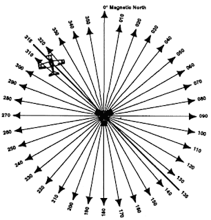
* 1 Principio de funcionamiento
* 2 Uso práctico
* 3 Precisión
* 4 Futuro
* 5 Véase también
* 6 Referencias
* 7 Enlaces externos
[editar] Principio de funcionamiento
La radiofrecuencia emitida por un VOR contiene o está modulada por tres señales. Una es la identificación de la estación en código Morse, que permite al piloto identificar la estación. Las otras dos son ondas senoidales de 30 Hz cuyas fases varían entre si. Se les llama señal de referencia y señal variable respectivamente. La referencia mantiene siempre su fase constante, mientras que la variable cambia su fase según la dirección en la que sea emitida. Dicha dirección se mide como un azimut, es decir, se divide en 360 grados alrededor de la antena VOR contando en sentido horario a partir del norte magnético terrestre, punto en el cual la señal de referencia y la variable tienen fase idéntica. De esta manera se puede visualizar una antena VOR como el punto desde el cual parten 360 líneas de dirección, a las que se les llama radiales.
El equipo VOR en la aeronave (avionics) recibe la señal VOR y demodula sus tres señales. Compara la señal de referencia con la variable y determina la diferencia de fase entre las dos. De esta manera puede conocerse en qué radial del VOR sintonizado se encuentra la aeronave con respecto al norte magnético terrestre.
Otra manera de verlo es que el radial obtenido por el equipo VOR de la aeronave, es el ángulo de desplazamiento entre el norte magnético y la aeronave, medido desde la antena de la estación terrestre VOR.
[editar] Uso práctico
El VOR se utiliza en la aeronáutica para navegar según el vuelo IFR, siempre permaneciendo en comunicación por radio con un controlador de tráfico aéreo (CTA). Los VOR suelen ir acompañados de otra radioayuda llamada DME (Distance Measurement Equipment), que ayuda al piloto a conocer la distancia que hay entre la aeronave y la estación VOR-DME. Los DME, aunque mayormente están instalados en la misma caseta que el VOR y comparten una misma instalación de antena (la del DME puesta directamente encima de la del VOR), son equipos completamente independientes del sistema VOR (a excepción de la señal de identificación, que se intercala en la del VOR). Al sintonizar el piloto la frecuencia de algún VOR en particular, automáticamente también se sintonizará la frecuencia de su DME asociado, y ambos compartirán la misma identificación en código Morse.
Un ejemplo de frecuencia y estación VOR-DME sería: RES (114.2 MHz) (y su transmisión en Morse: .-. . ...).
[editar] Precisión
La precisión predecible de un VOR es ± 1,4°. Sin embargo, datos de prueba indican que el 99,94% del tiempo con un sistema VOR tiene menos que ± 0,35° de error. Los sistemas VOR son internamente monitoreados y comunican cualquier error de la estación que exceda 1,0°.[1]
La norma ARINC 711-10 del 30 de enero de 2002 establece que la precisión del receptor debería estar dentro de 0,4º con una probabilidad estadística del 95% bajo varias condiciones. Cualquier receptor cumple con este estándar bien o suele excederla.
[editar] Futuro
Como ocurre con otras formas de radionavegación aérea utilizadas actualmente, es posible que el VOR sea reemplazado por sistemas satelitales como el GPS (Global Positioning System). El GPS es capaz de localizar la posición horizontal de una aeronave con un error de sólo 20 m. Si se utiliza el GPS combinado con el WAAS (Wide Area Augmentation System), el error se reduce a un cubo de 4 m de lado. Esta precisión instrumental se aproxima (con posicionamiento lateral y vertical) a la Categoría I de los sistemas ILS actuales (Instrument Landing System). Refinamientos posteriores incluyen el LAAS (Local Area Augmentation System), que probablemente permita aproximaciones equivalentes a la categoría III del ILS, para prácticamente aterrizar con cero visibilidad. El LAAS está planeado para utilizar una banda de frecuencia VHF para sus mensajes de corrección del GPS, lo cual requerirá que otras estaciones terrestres de radio locales (radionavegación o frecuencias de comunicación por voz) utilicen frecuencias diferentes para evitar interferencias.[2) ...FUENTE
Suscribirse a:
Entradas (Atom)