

Bienvenidos a este Blog en el cual solo se pretende subir información relacionada con el mundo de la aviación y la simulación de vuelo. Se irán subiendo videos, fotos, y noticias con la idea de informar y entretener al usuario en la medida de lo posible, siempre de una forma legal y sin animo de lucro. Sentiros como en casa. *** welcome to my blog, we have the intention to entertain and inform about interesting things related to aviation and simulation. I hope you enjoy!
miércoles, 19 de diciembre de 2012
lunes, 3 de diciembre de 2012
sábado, 1 de diciembre de 2012
miércoles, 17 de octubre de 2012
MANUAL DE VUELO
Muy buen manual de vuelo, de indispensable lectura para los noveles. Solo en castellano. Aqui os paso el
LINK

Flight Plan Creator
You have to see this!!!
*** Flight Plan Creator

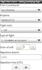
Be mobile! Create, share and archive your flight plans now easier then ever.With this application you can create your flight plan and store it in PDF format on your SD card (external storage).
Flight plan is formed in electronic CA48 format which can be used to file the flight plan without any modifications.
Useful feature is a possibility to predefine pilot and airplane information and use it during flight plan creation process.
Other features:
* view your flight plan in PDF on your mobile device. To use this feature you must have Android PDF reader installed. I suggest you use Adobe Reader which can be downloaded free of charge from Android market.
* share you flight plan using your installed sharing applications. List of possible sharing methods depends on installed applications (Dropbox, email, bluetooth, ...)
* you can access your flight plans from the SD card while the phone is connected to the PC in disk drive mode. Flight plan documents are stored on the SD card (external storage) in the "Flight_Plans" directory.
Note: delete flight plans from the application not from the external storage.
jueves, 27 de septiembre de 2012

lunes, 17 de septiembre de 2012
The Aviation Herald
Parte de incidencias varias en vuelo, muy interesante...
Incidents and News in Aviation. Very interesting...
*** The Aviation Herald

Incidents and News in Aviation. Very interesting...
*** The Aviation Herald

miércoles, 8 de agosto de 2012
Aircraft VOR Free
Aircraft VOR Free
*** HEREEE!!!!
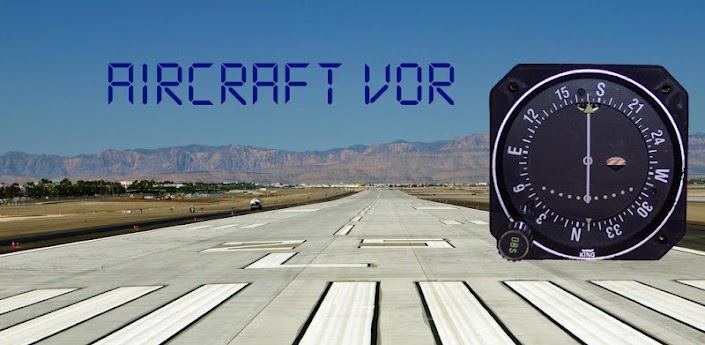
Aircraft VOR provides you with a GPS based aircraft VOR instrument shown as a typical Bendix/King KI-208A instrument.
It lets you 'tune' aircraft navigation Very High Frequency Omni-direction range (VOR) beacons via a worldwide database and allows you to select and track a VOR radial to or from the VOR station.
It also optionally shows you your cross-track deviation in metres.
Features:
- Bendix/King KI-208A face
- Worldwide VOR navigation database (downloaded on first use)
- Digital CRS and distance to station indications
- Option to display cross-track error
- Filtered and smoothed display - no jitter or jumping!
- Support for portrait and landscape screens
- Support for multiple screen resolutions
This is the free version of the app. It is supported by ads and has a five minute time limit. Upgrading to the paid version removes both of these restrictions.
Usage
IMPORTANT POINT 1 - Please ensure you have an active data connection when starting the app for the first time as it will attempt to download the radio navigation database.
Don't use it until you know its working!
Until a GPS fix is obtained, or in case of GPS fix being lost, the VOR on/off indicator will be shown and the distance to station will show ----
Tuning a station
Use the app menu to select 'Tune NAV'. You will be presented with all the VOR stations within 200 nautical miles of your current location. Selecting a VOR will tune it up. Hit your devices 'Back' button when you have selected your desired VOR.
Finding out which radial you currently on
The first thing to remember when trying to find out which radial you are on is that all radials are from the station. The indicator is able to show you which direction to track to the station but this is not directly which radial you are on (it's 180 degrees out). To centre the needle and find the radial you are currently on, rotate the instruments compass card until
the needle centres with a FROM indication.
Finding out your current bearing to the station
Sometimes it is necessary to obtain your current bearing to station. To obtain the bearing from your current position to the station, rotate the instruments compass card until the needle is centred and the TO flag is showing.
Flying a specific radial
Sometimes it is necessary to fly along a specific radial to/from the station. In this case, first select the radial you wish to fly by rotating the instruments compass card to that radial, ensuring the TO/FROM flag is in the correct sense. The VOR needle will then indicate to you which direction you need to move in order to intercept your desired radial. If the needle is to the right, fly right. If it is to the left, fly left. Upon approaching your desired radial, the needle will close into the centre. Each dot indicated on the display is 2 degrees, so the needle will start to move when you are within 10 degrees of the desired radial. You should begin to turn onto a desired course, which matches your radial so that your aircraft heading matches the desired radial when the needle is centred. You will need to compensate for wind appropriately.
Displaying X-Track deviation
You can display you current cross-track error in metres by toggling the menu option. This will show you the number of metres left or right of track when you close to less than 1km of your desired radial
For further information check out http://www.wikihow.com/Navigate-Using-a-VOR
If you like this app, please try my other aircraft/flying related apps!
I'm a professional software engineer, part-time android developer and passionate private pilot so would love to hear your thoughts, feature requests and bug reports
*** HEREEE!!!!
An aircraft navigation VOR receiver for you mobile device!
It lets you 'tune' aircraft navigation Very High Frequency Omni-direction range (VOR) beacons via a worldwide database and allows you to select and track a VOR radial to or from the VOR station.
It also optionally shows you your cross-track deviation in metres.
Features:
- Bendix/King KI-208A face
- Worldwide VOR navigation database (downloaded on first use)
- Digital CRS and distance to station indications
- Option to display cross-track error
- Filtered and smoothed display - no jitter or jumping!
- Support for portrait and landscape screens
- Support for multiple screen resolutions
This is the free version of the app. It is supported by ads and has a five minute time limit. Upgrading to the paid version removes both of these restrictions.
Usage
IMPORTANT POINT 1 - Please ensure you have an active data connection when starting the app for the first time as it will attempt to download the radio navigation database.
Don't use it until you know its working!
Until a GPS fix is obtained, or in case of GPS fix being lost, the VOR on/off indicator will be shown and the distance to station will show ----
Tuning a station
Use the app menu to select 'Tune NAV'. You will be presented with all the VOR stations within 200 nautical miles of your current location. Selecting a VOR will tune it up. Hit your devices 'Back' button when you have selected your desired VOR.
Finding out which radial you currently on
The first thing to remember when trying to find out which radial you are on is that all radials are from the station. The indicator is able to show you which direction to track to the station but this is not directly which radial you are on (it's 180 degrees out). To centre the needle and find the radial you are currently on, rotate the instruments compass card until
the needle centres with a FROM indication.
Finding out your current bearing to the station
Sometimes it is necessary to obtain your current bearing to station. To obtain the bearing from your current position to the station, rotate the instruments compass card until the needle is centred and the TO flag is showing.
Flying a specific radial
Sometimes it is necessary to fly along a specific radial to/from the station. In this case, first select the radial you wish to fly by rotating the instruments compass card to that radial, ensuring the TO/FROM flag is in the correct sense. The VOR needle will then indicate to you which direction you need to move in order to intercept your desired radial. If the needle is to the right, fly right. If it is to the left, fly left. Upon approaching your desired radial, the needle will close into the centre. Each dot indicated on the display is 2 degrees, so the needle will start to move when you are within 10 degrees of the desired radial. You should begin to turn onto a desired course, which matches your radial so that your aircraft heading matches the desired radial when the needle is centred. You will need to compensate for wind appropriately.
Displaying X-Track deviation
You can display you current cross-track error in metres by toggling the menu option. This will show you the number of metres left or right of track when you close to less than 1km of your desired radial
For further information check out http://www.wikihow.com/Navigate-Using-a-VOR
If you like this app, please try my other aircraft/flying related apps!
I'm a professional software engineer, part-time android developer and passionate private pilot so would love to hear your thoughts, feature requests and bug reports
Aircraft Horizon Free
Aircraft Horizon Free
*** HEREEE!!!!
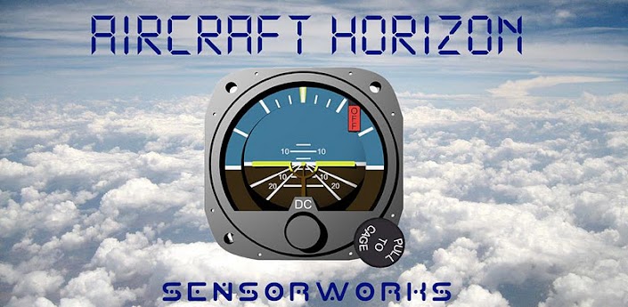
An aircraft artificial horizon on your phone!
Aircraft horizon is the most advanced artificial horizon on the marketplace.
It
fuses data from your devices accelerometer, gyro and magnetometer
sensors to provide you with accurate pitch and roll information depicted
as a typical aircraft artificial horizon.
Features:
- Sensor fused, accurate pitch and roll via internal accelerometer, gyro and magnetometer sensors
- Linear acceleration compensated - it is accurate whilst moving (with appropriate sensors)
- Automatically selects the best available sensors to use from those available on your device
- Filtered, smoothed and reactive display - no jitter or jumping!
- 'Pitch level' levels the horizon to your installation
- Supports multiple screen resolutions
- Supports display in both portrait and landscape orientations
This
is the free version of the app. It is ad supported and has a two minute
time limit. Upgrading to the paid version removes both of these
limitations.
Usage:
Aircraft Horizon is very simple to use. Pitch and roll is dynamically shown when you move your device. Using the menu, you can pitch level based upon your installation, switch between portrait and landscape modes and toggle debug data on and off.
Aircraft Horizon is very simple to use. Pitch and roll is dynamically shown when you move your device. Using the menu, you can pitch level based upon your installation, switch between portrait and landscape modes and toggle debug data on and off.
If you like this app, please try my other aircraft/flying related apps!
I'm
a professional software engineer, part-time android developer and
passionate private pilot so would love to hear your thoughts, feature
requests and bug reports.
Don't forget to rate it!
Aircraft Compass Free
Aircraft Compass Free for Android
*** HEREEEE!!!
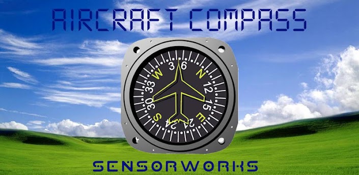
Aircraft Compass depicts an aircraft directional gyro complete with heading bug.
Aircraft
Compass provides magnetic compass and GPS ground-track functionality
depicted as an aircraft directional gyro, complete with a functioning
heading bug.It uses your phones internal sensors and global positioning system to present you with an accurate magnetic heading or ground-track.
Features:
- Magnetic heading sourced via internal accelerometer, gyro and magnetometer sensors
- Ground-track sourced via internal GPS
- Functioning heading bug (just drag with your finger!)
- Filtered and smoothed display - no jitter or jumping!
- Support for portrait and landscape screens
- Support for multiple screen resolutions
This is the free version of the app.
It is ad supported and has a two minute time limit per run. Upgrade to the paid version to remove both these limitations.
Usage:
Aircraft Compass is very simple to use. Move the heading bug by touching it and sliding it around. You can switch between magnetic heading and GPS based groundtrack using the menu, as well as changing between portrait and landscape modes
If you like this app, please try my other aircraft/flying related apps!
I'm a professional software engineer, part-time android developer and passionate private pilot so would love to hear your thoughts, feature requests and bug reports.
Aircraft ADF Free
Aircraft ADF Free for ANDROID
*** HEREEE!!!!
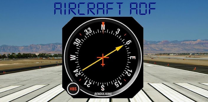
Aircraft ADF provides you with a GPS based aircraft radio magnetic indicator (RMI) instrument shown as a typical Bendix/King KI-227 instrument.
It lets you 'tune' aircraft navigation non-directional beacons (NDB) and gives you bearing and distance information to that NDB.
It uses a worldwide navigation database (downloaded on first use) and is not restricted by radio range.
It uses your device GPS position and heading to calculate bearing and distance to the tuned NDB.
This is the free version, with advertising and a five minute time limit. Upgrade to the paid version to remove both of these limitations.
Features:
- Bendix/King KI-227 face
- Worldwide NDB navigation database (downloaded on firt use)
- Digital Bearing and distance to station indications
- Option to operate as rotable compass card (just rotate with your finger!)
- Filtered and smoothed display - no jitter or jumping!
- Support for portrait and landscape screens
- Support for multiple screen resolutions
Usage
IMPORTANT POINT 1 - Please ensure you have an active data connection when starting the app for the first time as it will attempt to download the radio navigation database.
IMPORTANT POINT 2- To function correctly, the application requires not only a GPS position fix but also a valid GPS groundtrack. It may be necessary to move your device to give the GPS the data it requires to make this calculation.
Don't use it until you know its working!
Until a GPS fix is obtained, or in case of GPS fix being lost, the ADF will 'park' itself at 90 degrees and '---' will be shown in both the bearing and distance text boxes.
Tuning a station
Use the app menu to select 'Tune NDB'. You will be presented with all the NDB stations within 200 nautical miles of your current location. Selecting a NDB will tune it up. Hit your devices 'Back' button when you have selected your desired VOR.
Interpreting the display
If you have a valid GPS fix, the bearing to the NDB will be shown by the ADF needle and the top (or left in landscape mode) digital text box will show a digital bearing indication - the course you need to fly to travel towards the beacon. The distance in nautical miles to the NDB will be shown in the bottom (or right in landscape mode) digital text box.
Rotatable compass card
By default, the ADF compass card will slave itself to the GPS groundtrack, making the instrument a true single-needle Radio Magnetic Indicator(RMI). However, you can manually turn the ADF into a rotatable compass card instrument using the toggle option in the app menu. Once toggled, you can easily rotate the card using your finger.
If you like this app, please try my other aircraft/flying related apps!
I'm a professional software engineer, part-time android developer and passionate private pilot so would love to hear your thoughts, feature requests and bug reports
*** HEREEE!!!!
An aircraft navigation ADF receiver for you mobile device!
Aircraft ADF provides you with a GPS based aircraft radio magnetic indicator (RMI) instrument shown as a typical Bendix/King KI-227 instrument.
It lets you 'tune' aircraft navigation non-directional beacons (NDB) and gives you bearing and distance information to that NDB.
It uses a worldwide navigation database (downloaded on first use) and is not restricted by radio range.
It uses your device GPS position and heading to calculate bearing and distance to the tuned NDB.
This is the free version, with advertising and a five minute time limit. Upgrade to the paid version to remove both of these limitations.
Features:
- Bendix/King KI-227 face
- Worldwide NDB navigation database (downloaded on firt use)
- Digital Bearing and distance to station indications
- Option to operate as rotable compass card (just rotate with your finger!)
- Filtered and smoothed display - no jitter or jumping!
- Support for portrait and landscape screens
- Support for multiple screen resolutions
Usage
IMPORTANT POINT 1 - Please ensure you have an active data connection when starting the app for the first time as it will attempt to download the radio navigation database.
IMPORTANT POINT 2- To function correctly, the application requires not only a GPS position fix but also a valid GPS groundtrack. It may be necessary to move your device to give the GPS the data it requires to make this calculation.
Don't use it until you know its working!
Until a GPS fix is obtained, or in case of GPS fix being lost, the ADF will 'park' itself at 90 degrees and '---' will be shown in both the bearing and distance text boxes.
Tuning a station
Use the app menu to select 'Tune NDB'. You will be presented with all the NDB stations within 200 nautical miles of your current location. Selecting a NDB will tune it up. Hit your devices 'Back' button when you have selected your desired VOR.
Interpreting the display
If you have a valid GPS fix, the bearing to the NDB will be shown by the ADF needle and the top (or left in landscape mode) digital text box will show a digital bearing indication - the course you need to fly to travel towards the beacon. The distance in nautical miles to the NDB will be shown in the bottom (or right in landscape mode) digital text box.
Rotatable compass card
By default, the ADF compass card will slave itself to the GPS groundtrack, making the instrument a true single-needle Radio Magnetic Indicator(RMI). However, you can manually turn the ADF into a rotatable compass card instrument using the toggle option in the app menu. Once toggled, you can easily rotate the card using your finger.
If you like this app, please try my other aircraft/flying related apps!
I'm a professional software engineer, part-time android developer and passionate private pilot so would love to hear your thoughts, feature requests and bug reports
lunes, 16 de julio de 2012
domingo, 15 de julio de 2012
Visual approach and landing at San Sebastián, runway 22, on a CRJ 900
Visual approach and landing at San Sebastián, runway 22, on a CRJ 900
FS GLOBAL 2010 (FSX + FS9)

FS Global regresa al mercado con una nueva version: FS Global 2010. El nivel de detalle de la fuente de las elevaciones del terreno ha crecido enormemente. Mientras las versiones previas tenían unicamente 12 GB de datos en 6 DVDs, los datos de FS Global 2010 ha sido expandido a 12 DVDs incluyendo cerca de 25 GB. Y esto para cada versión!.
Se ha realizado una expansion de las elevaciones del terreno para las zonas de Escandinavia, Norteamérica, Siberia e Islandia con resoluciones hasta de 12 LOD. Se han realizado igualmente correcciones para darles a las montañas una apariencia mas real. 6 DVDs doble cara han sido incluidos en el paquete.
FS Global 2010 es un producto completamente nuevo (25GB = 12 DVDs/2 versions). Mayor resolución, mas areas cubiertas, nuevos algoritmos para mejores vistas! Ademas es compatible con FSX y FS2004. Ademas ha sido probado con Windows 7 e inferiores!
Características:
LOD12 (Datos fuente y elevaciones con resolución de 9m) para Hawaii (completa) y el suroeste de USA, sur de 38°N y oeste de 108°W (P.ej. Mesa Verde -> Point Reyes)
Cobertura de alta calidad en Norteamérica (y parte de.Canada!): LOD11 (19m).
Groenlandia, Islandia y Escandinavia con LOD 9 (76m; resolución estandar SRTM)
Areas adicionales de alta resolución en Europa en LOD11 (19m): High Tatra, Escocia, Hardangervidda (Noruega)
Areas al norte de Rusia en LOD9.
Antartica en LOD8
Nuevo algoritmo para corregir la altura de los picos
Nuevo algoritmo para reducer datos irrelevantes y facilitar la compresion
Nuevo algoritmo para encontrar y corregir errores
Parches para aeropuertos con problemas de elevacion
Herramienta para corregir los problemas de elevacion de los aeropuertos
FS Global 2010 X is a worldwide terrain mesh product for Flight Simulator 2004 / FSX. It adds 20 gigabytes of high resolution terrain elevation data to augment the fidelity of the virtual landscape features. This version follows FS Global 2008 which we looked at here on AVSIM back in February of 2008.
Like its predecessor, FS Global 2010 adds detail to the visible (above water) landscape features such as mountain ranges, fjords, peaks, gorges and other geographical points of visual interest. The product includes coverage the entire world (based on available data) in one package. There is no subset available for separate purchase. FSG 2010 includes data from new and updated data sources that are available commercially or in the public space, and converted to a format usable by the simulator.
jueves, 10 de mayo de 2012
Official Aerosoft Bronco X Promotional
ummm interesante...
Casi todos los aviones diseñados para operaciones militares de insurgencia son divertidos a pilotar. Estos deben ser agiles y poseer de potencia suficiente para escapar en caso de problemas asi como la capacidad para volar a proximidad del suelo. Esto los hace diferentes de los aviones comerciales que solo vuelan de un punto A a un punto B. El OV-10 Bronco es quizá el ejemplo mas evidente de este tipo de aviones.
Casi todos los aviones diseñados para operaciones militares de insurgencia son divertidos a pilotar. Estos deben ser agiles y poseer de potencia suficiente para escapar en caso de problemas asi como la capacidad para volar a proximidad del suelo. Esto los hace diferentes de los aviones comerciales que solo vuelan de un punto A a un punto B. El OV-10 Bronco es quizá el ejemplo mas evidente de este tipo de aviones.

viernes, 27 de abril de 2012

jueves, 26 de abril de 2012
domingo, 1 de abril de 2012
Just Planes
Just Planes produces the most popular series of Flight in the Cockpit Blu-rays & DVDs already featuring more than 230 airlines!!
*** justplanes

*** justplanes
miércoles, 21 de marzo de 2012

Solución definitiva para microfisuras del Airbus A380 en el 4º trimestre
Se reconoce que es el primer problema de este modelo
Solución definitiva para microfisuras del Airbus A380 en el 4º trimestre

*** Fuente Aviación Digital
Airbus lleva a cabo actualmente reparaciones temporales en algunos "pies de las nervaduras" de las alas de sus grandes aviones, en los que han aparecido microfisuras.
Simultáneamente, el fabricante busca una solución definitiva para reemplazar las piezas defectuosas -unas decenas de los 4.000 pies de nervatura con que cuenta un A380- que sujetan desde el interior el revestimiento de las alas a las nervaduras transversales.
"Esta solución estará disponible en el cuarto trimestre del año. Las reparaciones se realizarán entre finales de 2012 y 2013", declaró el portavoz.
Como no supone una urgencia absoluta, las compañías podrán programar dichas reparaciones en función de las citas de control previstas para cada aparato.
La Agencia Europea de Seguridad Aeronáutica (EASA) ordenó en febrero proceder al control de todos los A380 tras la aparición de estas microfisuras, aunque tanto ésta como el fabricantes aseguran que no presentan ningún peligro para la seguridad de los vuelos.
El primer A380 entró en servicio en octubre de 2007 en Singapore Airlines y en la actualidad hay 70 ejemplares volando. Estos aparatos con dos puentes pueden transportar hasta 800 viajeros.
Solución definitiva para microfisuras del Airbus A380 en el 4º trimestre
*** Fuente Aviación Digital
Airbus lleva a cabo actualmente reparaciones temporales en algunos "pies de las nervaduras" de las alas de sus grandes aviones, en los que han aparecido microfisuras.
Simultáneamente, el fabricante busca una solución definitiva para reemplazar las piezas defectuosas -unas decenas de los 4.000 pies de nervatura con que cuenta un A380- que sujetan desde el interior el revestimiento de las alas a las nervaduras transversales.
"Esta solución estará disponible en el cuarto trimestre del año. Las reparaciones se realizarán entre finales de 2012 y 2013", declaró el portavoz.
Como no supone una urgencia absoluta, las compañías podrán programar dichas reparaciones en función de las citas de control previstas para cada aparato.
La Agencia Europea de Seguridad Aeronáutica (EASA) ordenó en febrero proceder al control de todos los A380 tras la aparición de estas microfisuras, aunque tanto ésta como el fabricantes aseguran que no presentan ningún peligro para la seguridad de los vuelos.
El primer A380 entró en servicio en octubre de 2007 en Singapore Airlines y en la actualidad hay 70 ejemplares volando. Estos aparatos con dos puentes pueden transportar hasta 800 viajeros.
martes, 13 de marzo de 2012
lunes, 12 de marzo de 2012
Flight Sim Pilot Shop
*** Aqui hay cosas curiosas para simulacion --- nice things for simulation
Flight Sim Pilot Shop aqui

Flight Sim Pilot Shop aqui
jueves, 8 de marzo de 2012
miércoles, 7 de marzo de 2012
End of an Era MUST SEE!!!
One of the most awesome FS videos ever made!!!MUST SEE!!!
Uno de los mejores videos de FS jamas hechos!!! DEBER VERLO!!!
Uno de los mejores videos de FS jamas hechos!!! DEBER VERLO!!!
lunes, 5 de marzo de 2012


Su Majestad pilotó el A400M
*** Fuente Aviación digital

Su Majestad el Rey Don Juan Carlos I se ha convertido hoy en el primer Jefe de Estado que vuela en el Airbus Military A400M, el avión de transporte militar de nueva generación que se ensambla en Sevilla. Con el piloto jefe de pruebas "Military" de Airbus, Edward "Ed" Strongman, y el piloto de ensayos experimentales, Ignacio "Nacho" Lombo, el Rey de España realizó un vuelo local de unos 40 minutos de duración desde la base de Torrejón, cerca de Madrid.
Durante el vuelo, el Rey, habilitado como piloto militar, tomó los mandos del avión durante 20 minutos a una altitud de alrededor 10.000 pies y realizó una serie de maniobras, incluyendo virajes, y simulando el lanzamiento de carga humanitaria.
Su Majestad estuvo acompañado por el Ministro de Industria, José Manuel Soria, el presidente y consejero delegado de Airbus, Tom Enders, el presidente y consejero delegado de Airbus Military, Domingo Ureña y el responsable de ensayos en vuelo e integración de Airbus, Fernando Alonso.
La foto muestra al Rey Don Juan Carlos I con el responsable de ensayos en vuelo e integración de Airbus, Fernando Alonso, en la cabina del A400M.
Chile será escenario del primer vuelo con biocombustible de Sudamérica
*** Fuente

SANTIAGO.- Este miércoles sietede marzo, a las 10:30 horas, LAN Airlines llevará a cabo el primer vuelo comercial de una aerolínea de Sudamérica con el empleo de biocombustible, el cual tendrá como ruta las ciudades de Santiago y Concepción.
La iniciativa de carácter ecológico, se enmarca en una serie de medidas tomadas por la compañía para la preservación del medio ambiente, según señalaron.
La aerolínea chilena, que mantiene una flota con edad promedio de 6,9 años y una de las menores tasas de emisión de C02 de la industria, utiliza un sistema de aproximación llamado Required Navegation Performance (RNP) que permite el ahorro de ahorro de energía debido a que las rutas y aterrizajes llevan menos tiempo.
El acontecimiento, será el segundo que se realizará en Latinoamérica, ya que el año 2011 se llevó a cabo el primer vuelo a biocombustible de Latinoamérica en México por la empresa de vuelos domésticos Interjet, una de las aerolíneas más joven del país.
A diferencia de los combustibles fósiles, el biocombustible se produce orgánicamente y son renovables. Para su obtención se utilizan especies agrícolas como el maíz, mandioca, ricas en carbohidratos, o plantas oleaginosas como la soja, girasol y palmas, entre otros.


viernes, 2 de marzo de 2012
Flight Simulator Downloads and add-ons
Welcome to Fly Away Simulation flight simulator downloads section. Here you will find lots of freeware add-ons for all of the major flight simulators. We feature downloads for Microsoft Flight Simulator X, Flight Simulator 2004 and have just started featuring X-Plane downloads. Also included here will be files for Microsoft Flight, once the software has been released to the public. Adding additional aircraft or scenery to your flight sim is a great way to expand your experience and play for longer.
*** flyawaysimulation

*** flyawaysimulation
sábado, 25 de febrero de 2012
lunes, 20 de febrero de 2012
base de datos con Add ons gratis!!!
*** SIM-AVIATION
Base de datos con bastantes Add ons gratis!!!
Database with pretty add ons for free!!!

Base de datos con bastantes Add ons gratis!!!
Database with pretty add ons for free!!!

Add ons gratis
IBEROAVION: aviones gratis para Flight Simulator
www.iberoavion.com
Esta es una base de datos de aviones para el juego Flight Simulator. Desde aquí podrá bajar, en forma gratuita, aviones con los colores de líneas aéreas reales; para FS-2004, FS-2002, FS-2000 y FS-98.

*** Aquí
www.iberoavion.com
Esta es una base de datos de aviones para el juego Flight Simulator. Desde aquí podrá bajar, en forma gratuita, aviones con los colores de líneas aéreas reales; para FS-2004, FS-2002, FS-2000 y FS-98.
*** Aquí
Suscribirse a:
Entradas (Atom)